

THE public is set to have its say on plans which will transform Chelmsford in a move designed to prioritise cycling and walking.
Essex County Council has launched a public consultation on plans for a raft of changes in the city in a bid to encourage active travel.
Changes include creating "liveable neighbourhoods" - areas where it is easier and safer for you to walk and cycle - featuring measures to prevent cars using routes as a shortcut.
The council also wants to set up "school streets" which encourage children to walk and cycle to school.
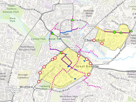
Three key routes in Chelmsford are set to be improved.
The huge new plans to transform Chelmsford in bid to boost walking and cycling
Here is what we know about each:
Route 1 - Railway station to Central Park
From the station the route follows the existing cycleway to Parkway.
At Parkway a new toucan crossing will be installed.
Located to the southeast of the existing subway, which will remain, the new crossing will provide a safer more direct route across Parkway, improving the line of sight for cyclists and reducing the potential for conflict with pedestrians.
The route continues through Central Park to the cycleway alongside the Virgin Active Gym on The Meads, before then turning east onto New Writtle Street.
To reduce traffic and enhance safety for cyclists, a modal filter will be installed on New Writtle Street.
This will then enable the residential area between New Writtle Street, New London Road, Lower Anchor Street and Upper Bridge Road to become a Liveable Neighbourhood with reduced traffic.
The route then travels along New Writtle Street with new road markings installed to make it clear to cyclists and drivers that this is a route designated for cycling.
On Moulsham Street, at the junction with New Writtle Street, new signs and lines will make it clear to drivers they will no longer be able to turn right into New Writtle Street.
To help people cycling and reduce the amount of traffic, a one-way ‘loop’ for all users will be installed along Grove Road and Hamlet Road.
It is proposed to make the local urban area of Moulsham a Liveable Neighbourhood.
This will see residents and businesses able to access their homes and premises via the appropriate quarter gateway, but modal filters put in place to stop any through traffic travelling within the neighbourhood.
Route 2 - Railway station to Tindal Square
The route travels via Burgess Springs and Victoria Road South to Market Road.
A segregated contraflow cycleway will be installed along Market Road for people cycling east.
The crossing on Market Road will be linked to the signalised crossing on Duke Street, which will be moved closer to the Market Road / Duke Street junction so that they work as one.
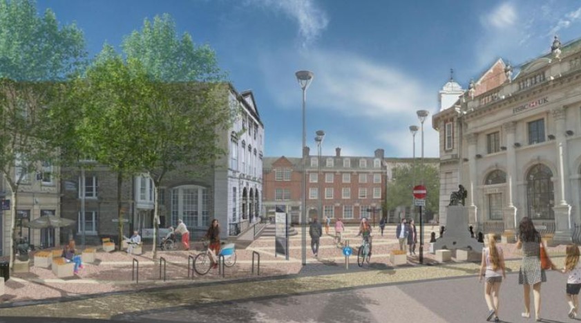
Essex County Council and Chelmsford City Council are due to deliver a new Tindal Square to improve the top end of the High Street.
The huge new plans to transform Chelmsford in bid to boost walking and cycling
As part of these works, general traffic is set to be prohibited, with walking and cycling remaining.
Continuing along Waterloo Lane, new cycle markings will support cyclists as they travel with the flow of traffic.
Reaching Riverside, the route then connects to the existing Riverside cycleway.
Read more:
- Chelmsford farm admits abstracting water illegally
- Chelmsford parents fined for failing to send children to school
- Best fish and chip shops in Chelmsford based on Google reviews
Route 3 - Springfield Allied Estate Liveable Neighbourhood
This area already benefits from a 20mph zone but this will be extended along Navigation Road and to Queen’s Road.
Upgraded signs and lines will be provided throughout to offer a safe environment for those walking and cycling.
Connecting from existing cycleways within Chelmer Village, the Chelmer Road junction with Sandford Road will be improved for cyclists and pedestrian crossing at this point.
The residential area along Springfield Park Road, where cycling is already popular within this existing 20mph zone, will benefit from enhancements for people cycling with a refresh of the 20mph markings and the introduction of cycle markings.
Working with Trinity Road Primary School, parents and the local community we will be looking to introduce a School Street zone during drop-off and pick-up times.
What has the council said about the plans?
Essex County Council has secured £7.3 million from the Government to make changes across Essex.
Lee Scott, councillor responsible for highways at Essex County Council, said: “We want Essex to be the walking and cycling county – a safer, greener, healthier place where we don’t automatically jump in the car, especially for shorter journeys.
“With over 90 per cent of Essex residents recently telling us that they were concerned about traffic congestion, air pollution and road safety, our ambitious aim is to make the transport network safer, greener and healthier, specifically designed for people who cycle and walk.
“With input from Essex residents, we can help transform the town centres and surrounding neighbourhoods into thriving and healthier areas with fewer cars but more people cycling and walking, allowing us all to breathe cleaner air and enjoy a better way of life.”
To view the plans and to comment, visit essexhighways.org/active-travel-fund.


Comments: Our rules
We want our comments to be a lively and valuable part of our community - a place where readers can debate and engage with the most important local issues. The ability to comment on our stories is a privilege, not a right, however, and that privilege may be withdrawn if it is abused or misused.
Please report any comments that break our rules.
Read the rules here